Think the Dells are all water slides and fudge shops? Push off just ten minutes from your Bonanza campsite and you’ll slip into side canyons where crystal springs bubble up like secret portals—so clear the kids will swear the fish are levitating.
Key Takeaways
– Hidden cold springs sit just a 10-minute paddle from Bonanza Campground in the Wisconsin Dells.
– Spring water stays about 50–55 °F all year, making it clear and refreshingly cool on hot days.
– Look for bright green plants, extra-clear water, or a sudden chill on your paddle to find a spring.
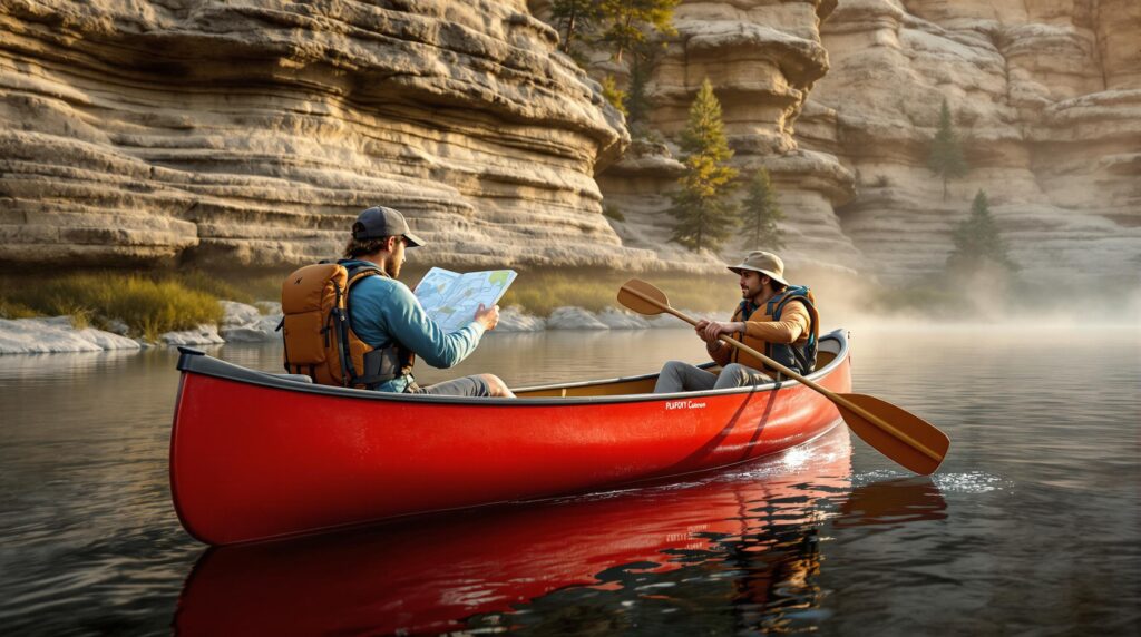
– Main beginner route: launch at Illinois Avenue ramp, paddle 3–4 miles upstream toward Witches Gulch, then drift back.
– Safety first: everyone wears a life jacket, carries a whistle, and keeps a waterproof-cased phone with an offline map.
– Best seasons: late May–June for the biggest cold-vs-warm surprise; October for colorful photos. Skip trips right after big storms or when river flow is high.
– Treat springs gently—stay in deeper water, don’t stir up sand, filter drinking water downstream, and pack out all trash.
– Rentals, shuttles, and gear are easy to book through Dells Watersports; Bonanza provides lockers, Wi-Fi, and a pool for downtime.
– Ready-made trip ideas fit families, couples, retirees, and digital nomads, so everyone can earn “explorer” bragging rights before lunch.
Whether you’re bribing the crew with a post-paddle splash session, hunting IG-gold for a weekend Reel, or craving a quiet, current-free glide, this guide walks you straight to the cold-water seeps hiding behind each sandstone bend—safe routes, snack stops, and GPS pins included.
Ready to earn explorer bragging rights before lunch? Grab a paddle, tap that next heading, and let’s start mapping.
The allure of the springs: why hunt for them?
Hidden springs are groundwater vents that hold a steady 50–55 °F year-round, producing crystal-clear upwellings and bright-green moss ribbons. Spotting one feels a bit like finding an underwater skylight: the river floor suddenly sharpens, and a cool surge skims your fingertips. That temperature shift alone makes them irresistible rest stops on a warm Wisconsin afternoon.
Families score a built-in science lesson without lecturing—dip a thermometer, compare readings, and watch the kids forget about screens. Weekend thrill couples get untouched backdrops for #SpringSeeker shots, especially when dusk paints the sandstone gold. Retirees appreciate the hush; alcoves muffle boat noise, so bird calls bounce off the canyon walls. Digital nomads collect B-roll and a mid-morning cold-plunge before the next Zoom session streams smoothly over Bonanza’s Wi-Fi.
Geology and history in one paddle stroke
The Lower Dells’ sculpted corridors exist because Cambrian sandstone erodes like layered cake. Over millennia, groundwater gnawed sideways through softer bands, leaving narrow passageways where springs now seep. Each striation in the cliff tells a chapter of ancient river levels, easy conversation fodder while kids tally color bands or couples line up depth-of-field photos.
Human stories run just as deep. Ho-Chunk families honored these pure outlets as spiritual and drinking-water sources, returning season after season to the same seeps. In the 1800s, keelboat crews filled canteens here, a tradition you’ll echo when you filter water downstream of the outlet. Understanding that lineage nudges paddlers to treat the springs as living heritage, not Instagram props.
Choosing your spring-finding route (10 minutes from Bonanza)
Most guests start at the paved Illinois Avenue ramp and paddle upstream toward Witches Gulch. The round-trip clocks roughly 7.5 miles of canyon twists, calm enough for beginners yet dramatic enough for drone footage; detailed turn-by-turn notes appear in this Wisconsin Dells paddling guide. Families like it because shuttle timing is simple: launch, explore, then drift back with the current.
If lake paddling feels safer, steer south to Lake Delton, slip under the highway into quiet Dell Creek, and portage the low dam into mirrored gorge water. Dells Watersports delivers canoes to either start and offers prepaid downstream pickup—book on their rental page when you reserve the boat to dodge end-day meltdowns. Long-weekend adventurers aiming for sandbar camping can push farther, tackling the 21-mile Prairie du Sac-to-Spring Green stretch, where dispersed beach camps line the Lower Wisconsin Riverway; this overview details sites and rules.
Base-camp prep: streamline the day
Bonanza works like a staging dock you sleep next to. Pack dry bags, extra water, and the lunchtime cooler in your vehicle or the campground’s hard-sided lockers so the canoe deck stays clutter-free. Because the Illinois Avenue lot fills fast, rolling out of camp at sunrise practically guarantees parking and glass-flat water for skill practice.
Rainy morning? Pivot. The heated pool, arcade, and Wi-Fi lounge absorb restless energy while you watch the flow gauge ease back into safe numbers. Bonus tip for parents: run a quick wet-exit drill in the pool the evening before; kids leave confident, and you get a quiet-mind night’s sleep.
Gear & safety essentials
Every paddler wears a properly fitted PFD, period. Clip a whistle to each vest and stash a backup air horn in the dry bag—canyon acoustics can swallow sound when you most need it. Quick-dry layers, brimmed hats, and a pocket thermometer round out the basics; shivering children sabotage photo ops faster than dead batteries.
Navigation starts with a waterproof-cased phone loaded with an offline USGS topo map and airplane mode engaged to preserve charge. Toss in plant bingo cards or fish-count lists to keep kids leaning in, not over the gunwales. Couples eyeing drone shots should confirm the craft’s return-to-home settings; GPS sometimes wobbles between cliff faces.
Field method: map a spring step by step
Before you even unstrap the canoe, open your mapping app, cue up satellite view, and drop a launch waypoint. Labeling now means less guessing later. While the crew slides paddles under thwarts, name a blank waypoint “candidate spring” so future pins stay organized.
On the water, let sensations guide you. A chill on your paddle? Mark the spot. Snap a shoreline photo that captures a crooked cedar or boulder silhouette for easy relocation, then dip the thermometer—anything under 55 °F earns a blue-star tag. Back at camp, sip something cold in the Wi-Fi lounge while exporting the GPX file, then trace an updated route line. Consistent symbols today equal cleaner maps next vacation.
Detecting springs in real time
Trust your eyes first. Look for neon-green vegetation streaking down otherwise tan rock—or watch for tiny upstream ripples where side alcove water appears to fight the current. If you waggle your fingers in the river and clarity suddenly improves, you’ve probably crossed an invisible spring boundary.
Thermal clues seal the deal. Cold bands travel in narrow lanes; slide the canoe sideways a few feet and you might step back into 70-degree mainstream warmth. Practice this “temperature dance” with kids and they’ll forget every screen in reach.
Timing your trip for maximum “wow”
Late May through June delivers the largest temperature spread between river and spring, making cold plumes pop. Thunderstorm runoff, however, clouds the water—wait at least 24 hours post-storm so suspended sediment settles and moss stripes reappear. Calmer flow also lets beginners maneuver more confidently, giving every paddler time to pause and savor the spectacle.
Photographers flock in October when leaf-off exposes seep-fed ribbons otherwise hidden by summer foliage. Any month, though, check daily cubic-feet-per-second numbers; if flow doubles the seasonal average, postpone. High water both masks small springs and bolts through canyon pinch-points faster than novices can react.
Respect fragile spring mouths
Keep your bow in deeper water and explore with your eyes, not the paddle. Shoving into a shallow seep stirs silt that smothers aquatic invertebrates dependent on clean gravel. When you do step out, choose sand or bare rock—moss patches crunch once and never fully recover.
Filter drinking water downstream of the outlet, not at the source. Pocket a mesh trash bag for micro-litter that blows off snack wrappers, and if you stumble on a spring nobody’s charted, resist stacking cairns or painting arrows. Quiet documentation protects rare seeps from crowding and vandalism.
Sample itineraries you can copy today
Families pressed for time can opt for a Half-Day Spring Bingo route. Launching at 8 a.m. gets everyone on glassy water, and the first cold seep appears before kids ask the classic “Are we there yet?” Packing snacks for a sunny beach two miles upstream ensures you’re back by noon for the Mt. Olympus slides, with every young explorer proudly comparing fish tallies.
Couples chasing golden-hour magic might shove off at 5 p.m. for canyon walls that glow orange, while retirees preferring mid-week hush will love a Tuesday drift at three miles per hour that still leaves room for a Mirror Lake ranger talk. Digital nomads can film fog-shrouded drone footage at dawn, mark three new springs before lunch, and return to camp’s Wi-Fi strong enough for a 2 p.m. video call. Whatever your crew’s style, each itinerary layers discovery, downtime, and brag-worthy moments into a schedule that actually sticks.
Rental, shuttle & contact quick-links
Reserve boats, paddles, and life jackets in one swipe on the Dells Watersports site; shuttle drivers confirm pickup windows during checkout. For real-time water levels, bookmark the USGS Lower Dells flow gauge and pair it with NOAA’s hourly forecast widget. Bonanza’s front desk supplies locker codes, pool hours, and local taxi numbers in case weather forces a mid-route exit.
Save emergency details in your phone before launching: the Sauk County sheriff’s non-emergency line, the nearest urgent-care address, and Bonanza’s after-hours number. Travelers relying on rideshares should schedule return pickups in advance, since coverage thins out after dusk. Printing a paper copy of your route lends an extra safety margin should batteries fail.
Post-paddle wind-down at Bonanza
Rinse mud and grit off boats at the bathhouse spigot before seats or buckles grind themselves ragged. Then plop onto the Wi-Fi lounge couch, upload today’s GPS file, and compare spring pins with neighbors around the community fire pit—some of the best discoveries spread over marshmallow smoke. Finish with a lap in the heated pool to unknot paddle-tired shoulders and prime everyone for s’mores.
If energy still buzzes, stroll the campground loop to spot fireflies winking between pines while the sun’s last embers fade. Early risers can prep tomorrow’s breakfast in the camp kitchen, knowing a clean deck and organized dry bags cut launch stress in half. By the time lanterns click off, the hush of the surrounding woods will have replaced the river’s steady cadence in your ears.
Those blue-star pins won’t plot themselves—so claim your launchpad at Bonanza Camping Resort, wake to birdsong just minutes from the Illinois Avenue ramp, and be on the water before the crowds ripple in. Whether you need a shaded tent site, a full-hookup RV pad, or a cozy cabin where tomorrow’s route can unspool over s’mores, our north-woods basecamp keeps your gear dry, your Wi-Fi strong, and your crew smiling. Reserve your stay today, then come trace those hidden cold-water threads knowing hot showers, a heated pool, and a campfire circle are waiting at day’s end. Adventure is the map; Bonanza is the legend.
Frequently Asked Questions
Q: How long is the paddle from the Illinois Avenue ramp to the first spring, and can kids handle it?
A: The first reliable spring sits just over one mile upstream—about 25 steady minutes for average paddlers—so most eight-year-olds, with a fitted PFD and adult guidance, reach it before the “Are we there yet?” kicks in.
Q: Are bathrooms or snack stops available along the route?
A: The riverbanks are primitive, but two sandy pull-outs within the first three miles offer room for a quick picnic or privacy break; use the campground restrooms before launch and pack a sealable bag to haul out any tissue.
Q: What’s the best time of day to find glassy water for photos and drone shots?
A: Sunrise to roughly 9 a.m. delivers the flattest water and fewest tour boats, while golden hour after 5 p.m. adds warm canyon light; both windows still leave room to be back at Bonanza for midday Zoom calls or evening campfires.
Q: Can I rent all the gear on-site, or should I bring my own kayak and PFD?
A: Dells Watersports will meet you at the launch with canoe, kayak, paddles, and Coast Guard–approved life vests; if you love your personal boat, feel free to BYO and use the paved ramp at no extra charge.
Q: Is the route safe for retirees with limited mobility and no interest in portaging?
A: Yes—this stretch is flatwater with no required carries, and you can turn around at any point; choose a weekday morning for the quietest conditions and keep your pace leisurely.
Q: How reliable is cell service along the canyon for livestreaming or emergency calls?
A: Most carriers hold two to three bars in open bends and drop to one bar in tight gulches, enough for voice calls but choppy video; record content offline and upload once you’re back on Bonanza’s strong Wi-Fi.
Q: Are pets allowed in the canoe and at spring pull-outs?
A: Well-behaved dogs on leash are welcome in rental canoes and on sandbars; just pack a life jacket made for pups and bring waste bags so springs stay pristine.
Q: Does water temperature ever get too cold for kids to wade near a spring?
A: Spring water hovers between 50–55 °F year-round, which feels brisk but safe for short foot soaks; keep immersion brief, dry kids quickly, and have a towel and dry socks ready.
Q: What flow level is considered “too high” to hunt springs safely?
A: If the USGS Lower Dells gauge spikes to more than double the seasonal average—usually above 6,000 cfs—skip the trip, as murky fast water masks the seeps and reduces maneuver time.
Q: Are there guided tours or ranger talks focused on the springs?
A: Private guides can be arranged through Dells Watersports for two-hour spring tours, and the Mirror Lake State Park ranger hosts a Tuesday 2 p.m. chat on local geology that pairs nicely with a morning paddle.
Q: Can we fit the spring exploration in before an afternoon waterpark session?
A: Launch by 8 a.m., paddle up to two springs, and drift back for a noon take-out, leaving plenty of margin to shower and hit the slides after lunch.
Q: Where’s the quietest spot for a picnic without motorboat wake?
A: A moss-rimmed alcove one and a half miles upstream, shielded by a sandstone elbow, blocks wake entirely and offers shade plus bird calls instead of engine noise.
Q: Are printed maps available for those who prefer paper over apps?
A: Grab a free waterproof trifold map at the Bonanza front desk; it marks mile intervals, the three most reliable springs, and safe exit points.
Q: How do we minimize our impact on these fragile spring mouths?
A: Stay in knee-deep or deeper water, avoid stepping on green moss carpets, filter drinking water downstream, and pack out every crumb so future paddlers see the springs as untouched as you did.